
profile/62691662065208567.jpg
GistHub
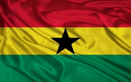
What You Need To Know About Ghana
~1.8 mins read
Ghana is a country in West Africa. Ghana, officially the Republic of Ghana, is a country along the Gulf of Guinea and the Atlantic Ocean, in the subregion of West Africa. The population is about 29.77 million as at 2018. The President is none other than the great Nana Akufo-Addo.
Formerly known as the Gold Coast, Ghana gained independence from Britain in 1957, becoming the first sub-Saharan nation to break free from colonial rule. Gold, cocoa and more recently oil form the cornerstone of Ghana's economy and have helped fuel an economic boom.
Gulf of Guinea. It is surrounded (clockwise, from the west) by Côte d'Ivoire, Burkina Faso, Togo. Ghanahas ten regions: Greater Accra, Ashanti, Brong Ahafo, Central, Eastern, Northern, Upper East, Upper West, Volta too.
How rich is Ghana?
Ghana is Africa's second-biggest gold producer (after South Africa) and second-largest cocoa producer. It is also rich in diamonds, manganese ore, bauxite, and oil.
Is Ghana safe?
Ghana is a very safe, stable country with very low crime levels compared to many other countries though they claim people migrate to the country illegally to start doing business.
Most Ghanaian ladies drool over Nigerian men and prefer them to their men, we are yet to know the reason behind this.
Some facts about Ghana:
1. Ghana was the first country in West Africa to gain independence from their colonial masters, the British. The weird fact about Ghana is independence was gain by a group of black people, the British never thought could come together to achieve anything. Well done, freedom fighters.
2. The Ghanaian people are a nation originating in the Ghanaian Gold Coast. Ghanaianspredominantly inhabit the republic of Ghana, and are the predominant cultural group and residents of Ghana, numbering 20 million people as of 2013. Native Ghanaians make up 85.4% of the total population.
3. According to William the truck driver Ghanaians are happy because everyone is friendly and everyone is friendly, because they live a lifestyle committed to the purpose of Jesus, God, Allah, or what ever being they chose to put their faith in.
4. Some inhabitants of present Ghana had ancestors linked with the medieval Ghana. This can be traced down to the Mande and Voltaic peoeple of Northern Ghana--Mamprussi,Dagomba and the Gonja.
5.Historically, we can confidently say the Ashanti'sare by far the richest sect of Ghanaians by birth. Born into riches, they are destined for wealth by inheritance. Many Ashanti's acquire their starting capital from their fathers and forefathers.
profile/62691662065208567.jpg
GistHub
Too Tourists Centers In Nigeria
~6.9 mins read
There are many tourist attractions in Nigeria we think both the state and federal government needs to pay more attention.
We actually have witnessed a spike in the number of tourists coming to see the sights of the most populated black nation and these tourists often end up seeing just a fraction of what the whole country has to offer.
For this reason, here is a list of five top natural attractions in Nigeria:
A. The Mambilla Plateau:
The name "Mambilla" is a derivative of the ancient name "Mamberre" which has been used for the Mambilla Plateau from ancient times and which concomitantly denotes its inhabitants.
The Mambilla Plateau is a plateau in the Taraba State of Nigeria. The plateau is Nigeria's northern continuation of the Bamenda Highlands of Cameroon. The Mambilla Plateau has an average elevation of about 1,600 metres above sea level, making it the highest plateau in Nigeria.
The Plateau measures about 96 km (60 mi) along its curved length; it is 40 km (25 mi) wide and is bounded by an escarpment that is about 900 m (2,953 ft) high in some places.[4] The plateau covers an area of over 9,389 square kilometres (3,625 sq mi).[5] Gang ('Chappal Waddi') Mountain is found at the northeastern flank of the Plateau.
It has an average elevation of about 1,600 metres (5,249 ft) above sea level, making it the highest plateau in Nigeria.[1] Some of its villages are situated on hills that must be at least 1,828 metres (5,997 ft) high above sea level.[2]
Some mountains on the plateau and around it are over 2,000 metres (6,562 ft) high, like the Chappal Waddi (more appropriate name: Gang) mountain which has an average height of about 2,419 metres (7,936 ft) above sea level. It is the highest mountain in Nigeria[3]and the highest mountain in West Africa if Cameroon's mountains, such as Mount Cameroon, are excluded.
The plateau has its south and eastern escarpments standing along the Cameroonian border, while the remainder of its giant northern escarpment and its western slope are in Nigeria.
Who are the inhabitants of the plateau?
People:
The major, original and predominant group of the Mambilla Plateau are the Fulani and Mambilla. Since the British occupation and thereafter, there has been immigration of other groups including the Kaka, and trading communities of Igbo, Wimbum (Kambu), Hausa and Banso. The major Languages spoken on the Mambilla Plateau are Fulfulde (the language of the predominant population, (used for commercial transactions by various groups), mambilla, Kaka, Banso, Igbo, etc. English is used as official language. Note, however, that only the Fulani,Mambilla and Kaka have existing villages while the Fulanis established cattle-farm settlements nestling between these villages in British times. Christianity and Islam are the main religions today, having gradually displaced the Mambilla Traditional Religion based on Suu, which was the predominant religion before the coming of White missionaries and Hausa-Fulanis; and particularly before the 1970s.
Also, the plateau is dissected by many streams and rivers; notably among them are the Donga River and Taraba River, with both having their sources on/from the Mambilla Plateau.
Some things you need to know about the plateau:
1. The Mambilla Plateau, cradle of the Bantu-speaking peoples.
2. It is continuously inhabited for over four millennia by the Mambillobantu culture which is found in the southeastern part of Taraba State of Nigeria under Sardauna local government area.
3. The plateau is also mosquito and tse-tse fly free.
4. The climate of the plateau is comparatively cold.
5. Vegetation on the plateau comprises low grasses with trees being noticeably absent except for man-made forest planted by German colonialist during the period of German administration of the cameroons.
6. The plateau is the only region of Nigeria that grows the tea plant on a large scale, and there are several tea farms, although the sector remains mostly underdeveloped.
7. The abundance of low lush green grasses on the plateau has attracted a large number of cattle.
8. The Mambilla Plateau receives over 1850 millimetres of rainfall annually.
9. Daytime temperatures hardly ever exceed 25 °C (77.0 °F) making it the coolest region in Nigeria.
10. The Mambilla Plateau is hilly with deep gorges and travelers are constantly passing from one panoramic view to the other.
11. The plateau is entirely covered by soil with occasional occurrence of granite.
We should also put it at the back of our minds that the rainy season on the Mambilla Plateau is associated with frequent and heavy rainfall due to orographic activities on the plateau involving moist winds from the south Atlantic Ocean in southern Nigeria and the steep edges and escarpments of the plateau.
See photos of what the plateau looks like below:
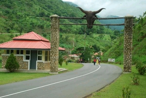
B. The Obudu Plateau:
Obudu is a place in the Cross River State of Nigeria. Obudu is a center of attraction and has been welcoming many tourists around the globe for many years. Obudu Plateau is a plateau found on the Oshie Ridge of the Sankwala Mountain range, in Cross River State, in the southeast of Nigeria. The plateau is found in Obanliku local government area of the Cross river state. It extends towards Nigeria's south eastern border. There is also a mountain within that particular area known as ‘Sankwala mountain’, this mountain ranges were first explored in 1949 by McCaughley, a Scottishrancher who camped out in the mountains for a month, before returning with Hugh Jones – a fellow rancher who, in 1951, together with Crawfeild developed a cattle ranch on the plateau known as the ‘Mountain Resorts.’
Mountain Resort (formerly known as the Obudu Cattle Ranch) is a ranch and resort on the Obudu Plateau in Cross River State, Nigeria. He camped on the mountain top of the Oshie Ridge on the Sankwala Mountains for a month before returning with Mr. Hugh Jones, a fellow rancher, in 1951. Together with Dr Crawfeild, they developed the Obudu Cattle Ranch.
Since 2005, a cable car climbing 870 metres (2,850 ft) from the base to the top of the plateau gives visitors a scenic view while bypassing the extremely winding road to the top. The resort is found on the Obudu Plateau, close to the Cameroon border in the northeastern part of Cross River State, approximately 110 kilometres (68 mi) east of the town of Ogoja and 65 kilometres (40 mi) from the town of Obudu in Obanliku Local Government Area of Cross River State. It is about 30 minutes drive from Obudu town and is about a 332 kilometres (206 mi) drive from Calabar, the Cross River State capital. Charter air service is available to the Bebi Airport which lies between the village of Obudu and the resort.however, the Air strip is no longer functional and the cable car has been grounded for a while now.
The climate of the Obudu Cattle Ranch is semi-temperate mountain climate, which is the general weather condition experienced on the Obudu Plateau due to its 1,600 metres (5,200 ft) elevation.
The ranch has been through troubles since, it has very recently been rehabilitated to its former glory by the South African Protea hotel chain.
A Few Things you need to know about Mountain Resorts/Obudu Plateau:
1. The Plateau is home to a cattle ranch popularly known as the Obudu Cattle Ranch. The ranch is approximately 65 km from Obudu town, in the northeastern part of Cross River State.
2. An airstrip is located at the foot of the plateau for visitors reaching the plateau by air from other parts of the world.
3. A cable car transport network takes visitors from the foot of the mountain to the top of the plateau.
4. The plateau has a tourist lodge, built at an altitude of about 1600 metres above sea level.
5. The terrain of the Obudu Plateau is hilly with deep gorges.
6. A total of 4,200 millimeters of rainfall is received on the plateau between April to November.
7. The plateau experiences a semi-temperate climate, with temperatures going between 26 °C (78.8 °F) to 32 °C (89.6 °F) during the dry season of November to January.
We should also note that the Orographic activity is a factor contributing to the heavy rainfall. Clouds coming into southern Nigeria from the Atlantic Ocean drop their moisture content onto the plateau as the barrier of the Sankwala mountains forces the cloud upward and the resulting rapid cooling is followed by heavy rainfall on the plateau.
However, the ranch has in recent times seen an influx of both Nigerian and international tourists because of the development of tourist facilities by Cross-River State Government, which has turned the ranch into a well known holiday and tourist resort center in Nigeria. Its has a serene climate compared to other regions in Nigeria.
Take a look at these photos of the plateau:
C. Ngwo Pine Forest:
The unique forest dynasty that is found in Ngwo Pine is a huge draw for visitors, romantically set by Mother Nature with sharp twists for adventure seekers, beautifully set pine trees and gently flowing stream for lovers, and the loud splashing of the waters inside the dark cleft inside a cave would blow off one’s imagination.
Location: Ngwo, Enugu State
D. The Sukur Landscape:
Madageli- is the home of the Sukur cultural landscape is populated with traditional cemeteries and ritual terraced areas. Blessed with lush avifauna and situated on top of the Mandara Mountains. It is a UNESCO World Heritage Site.
Location: Madageli, Adamawa State
E. The Ancient Nok Settlement:
All over the world, the antiquities from the Ancient Nok Settlement are seen in galleries and museums. This little archaeologists’ haven is located in Jaba Local government. It was here that the Terracotta figurine was discovered in the world.
Location: Jaba , Kaduna State
Advertisement

Link socials
Matches
Loading...